Laddar...
Background and Assignment
In fulfillment of the assignment I received to investigate the soil conditions for canal construction at the Persberg and Nordmark mining areas, with the intention to lead water from Horrsjön near Kalkkulls Gruva for ore extraction and water lifting in several mines, and subsequently to direct the water from Grundsjön in the most suitable way to Brattfors and Grundsjö mines for ore transport, including preparation of plans, profile maps, and cost estimates for these canal works, I have now completed this task and have the honor to submit it.
Survey at Persberget
At the beginning of the survey for the canal at Persberget on September 20, I enlisted the assistance of Mechanical Assistant and Conductor Erik Sandberg and later Surveyor Apprentice Jan L. Rydstedt. Initially, without instruments, we walked the areas to find the most suitable route for the canal. Bergs Sixman Carl Erson Skafnäset, familiar with the terrain, accompanied us. Several obstacles were encountered at first, especially the high elevation of the land relative to the water level at Horrsjön, from which the water was to be diverted.
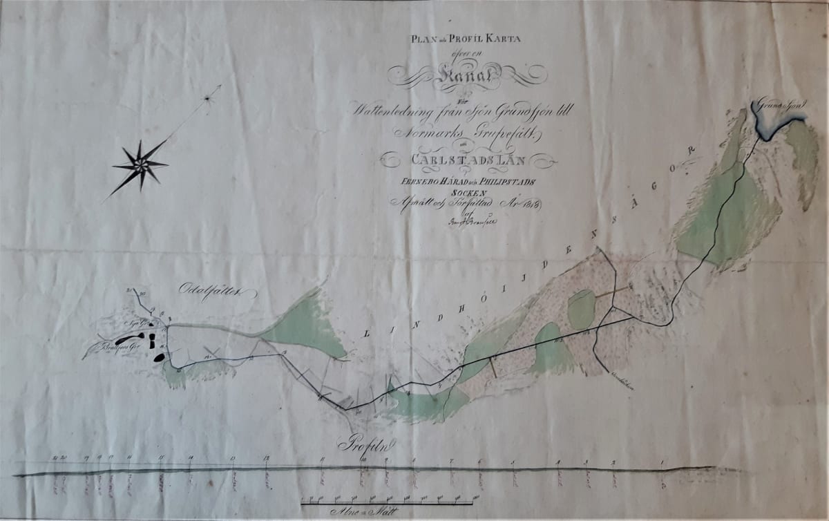
Measurements and Canal Route
Through our continuous efforts, we finally identified the canal route now indicated on the map. I traveled home to retrieve my instruments, which Sandberg, Rydstedt, and I then used to continue measurements under favorable weather conditions. After the canal line was measured and found suitable, Yngshytteälven was surveyed from Horrsjön to Yngen to provide references for canal measurement, including three correction lines with a difference of 1 to 6 inches (1–1.8 m), which is negligible in the overall scheme.
Canal and Drop Heights
The canal begins at Horrsjön, passes through a large marsh, and continues with several bends through hills, bogs, and ponds up to the road between Yngshytte and Saxå Gästgiverigårdar. There it passes under the road and through a small property, then continues through forested land to Nolandsmossen, where a 28-foot (8.3 m) drop occurs, which cannot be avoided. A waterwheel can be installed here to serve the Jordås and Malmbergskärr mines and others in the area. Yngshytte’s privileged mill and saw should be moved, as all driving water from these works returns to the canal.
To lead water upstream, several side dams must be built of stone, as otherwise, due to land slope, water would flow toward Yngshyttan. Attempts to raise the water level to avoid these dams would make the canal much longer, more winding, and more costly. Costs for building these dams and necessary bridges are included in the budget.
Nordmark and Advantages
At Nordmark, where the canal is shorter and less costly than at Persberget, ore lifting at Brattfors and Grundsjö mines can mostly be accomplished by water power via a small branch from the main canal. Taberg mines can also be served by lifting wheels if water supply permits, especially if ponds from which Ormbäckens waters flow are dammed, as water wheels on these sites can operate with a 40-foot (≈12 m) fall.
The plan and profile maps for both Nordmark and Persberget clearly show the canal alignment, length, and ground levels relative to horizontal. This allows elimination of long and costly water contrivances that, with increasing mine depth, would otherwise not be effective. Ore lifting wheels can be installed at Stor, Kran, and Kalkkulls mines at minimal cost, and shorter power conduits require only maintenance at other mines, including Högbergsfältet.
Conclusion
Additionally, forests belonging to the mining fields are spared, which otherwise would be heavily exploited for new construction and repairs of long conduits, leaving insufficient timber for necessary works. Finally, I note that without the mentioned assistants, who worked with me continuously, I could not complete this work this autumn.
Glänne, November 28, 1818
Transcription: Bengt Bransell, Persbergs and Grundsjö canal, 1818
Persberg, January 24, 2023, T. Nordwall