Laddar...
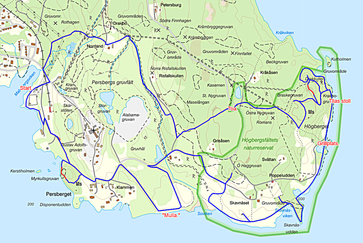
Ledens längd: Ca: 8 km.
Information
The trail has two red-marked sections that require strong legs and good mobility.
To navigate along the trail, switch between the Swedish Mapping Authority’s “Min Karta,” where your position is shown on the map, and the map of the Högberg Promenade. The “Min Karta” app can be downloaded using the attached link.
If you would like to learn more about the industrial-historical remains along the trail, you can scan the QR codes placed along the path.
Discover Högberget
There is much more to see at Högberget than the popular Krakbogruvan with Tilas stoll. Take your time to explore:
- The memorial stone commemorating the miners’ strike of 1869
- Yngshyttegruvan with its dramatic history
- Drakkullen – locally known as “Vargkullen”
From Drakkullen you can enjoy both refreshments and a magnificent view to the east. Closest lies Kutviken with Kutholmen. Further out on the lake you can see the Bårsholmarna islands, and on the opposite side of Yngen lies the village of Båren.
Towards Skavnäsudden
When you have finished exploring Högberget and Tilas adit, follow the shoreline of Lake Yngen southwards to the reserve’s barbecue area.
Continue along the lake to Skavnäsudden. At the very tip of the peninsula you will find a lovely place for a coffee break. Skavnäsets kapell with its beautiful burial ground, as well as the bell tower further west, are well worth a visit.
The trail then continues along the lake through cultivated countryside towards the Östra Hage mines and out onto Högbergsvägen.
Mulldammen and Swimming
Follow the road past Österholm and walk out onto “Mulldammen” to enjoy the view over the southern parts of Lake Yngen. At “Mulla” you can take a swim in the crystal-clear water.
Continue across the dam and back to Högbergsvägen. Soon you will reach the road down to Persberg Manor, where the path towards Myrkullen begins – often called Persberg’s “High Coast.”
From Myrkullen you have another beautiful view over Lake Yngen: Kerstiholmarna closest, Vinternäset to the west, and Storön to the south.